Training Log Archive: PGIn the 7 days ending Oct 20, 2007:
| ||||||||||||||||||||||||||||||||||||||||||||||||||||||||||||||||||||||||||||||||||||||||||||
| « | » |
| » now | ||||||||||
| Su | Mo | Tu | We | Th | Fr | Sa | |||||||
Saturday Oct 20, 2007 #
Event: Big Blues Ramble 2007
trail running 10:00 [2]
shoes: integrators 2006
Warm-up.
orienteering 39:34 [4] 5.1 km (7:45 / km) +59ft 7:37 / km
shoes: integrators 2006
Big Blues Ramble, middle distance, M45 (Red). Put out a good effort but not much to show for it as my orienteering was woefully deficient, mistakes on 1, 2, 5, 8, and 10 (out of 13 controls), probably 7 minutes total. Plus rolled my right ankle again on the way to 10, hurt a lot, but just kept moving and it slowly mellowed out and at the end, maybe 7-8 minutes later, it wasn't bad at all.
Good forest, quite flat, got the better of me.
I'll post maps when I get home.
Good forest, quite flat, got the better of me.
I'll post maps when I get home.
trail running 5:00 [3]
shoes: integrators 2006
Had something to eat and drink, took 800 mg Vitamin I, and after a bit it was time for the sprint. Warm-up/test -- ankle felt a little twingy, not bad at all.
orienteering 13:28 [4] 2.2 km (6:07 / km) +30ft 6:00 / km
shoes: integrators 2006
Big Blues Ramble sprint, fundraiser for the team (thanks, Joe!!) and opening event in the 2008 Sprint Series. Another good effort, acceptable result given my current form, best was Will Hawkins in 10:20.
Beautiful day, very pleasant meet site, good vibes, glad I came.
Beautiful day, very pleasant meet site, good vibes, glad I came.
Thursday Oct 18, 2007 #
track 12:47 [4] 2.0 mi (6:23 / mi)
weight:138lbs shoes: Montrail
Thursday evening track group, last one of the year, getting rather dark. Whatever good legs I had yesterday didn't show up today. So given the choice of staying close to my planned times and running out of gas early, or slowing down and doing the whole workout, I opted for the former.
1200, 800, 800, 400, not much rest (cycle was equivalent to 8-minute pace), 4:55, 3:13, 3:12, 86.8. Plan was 4:50, 3:10, 3:10, 90, and then repeat, but something had to give. Ran the 400 faster and then wisely quit.
Now I'll have to try to keep doing this on my own.
1200, 800, 800, 400, not much rest (cycle was equivalent to 8-minute pace), 4:55, 3:13, 3:12, 86.8. Plan was 4:50, 3:10, 3:10, 90, and then repeat, but something had to give. Ran the 400 faster and then wisely quit.
Now I'll have to try to keep doing this on my own.
track 8:28 [2] 1.0 mi (8:28 / mi)
shoes: Montrail
Warm-up.
Wednesday Oct 17, 2007 #
trail running 1:09:32 [3]
weight:138lbs shoes: Montrail #2
With Phil, from Mill River to Depot Road and back. Relaxed pace, legs felt good, especially for an ice-cream inhaling sextagenarian! Even though I have been living more on cake than ice cream the last couple of days. Maybe that's the secret.
Very pleasant afternoon. One garter snake, three deer, one hunter, no falls. Working hard enough to feel like it was an effort, but also always felt I could have gone quicker. Very nice.
Spent part of the run thinking about a couple of e-mails that annoyed me, Got that out of my system, figured out what to do on the way home. As usual, the response I really want to make is not the one that will be made. I thought I had reached the age where I could say exactly what I felt like saying, anyone else be damned, but apparently I'm not quite there yet. Maybe 64?
Tuesday Oct 16, 2007 #
trail running 56:30 [3]
weight:137lbs shoes: Montrail #2
I was out in the NW corner of the state and just before I left I grabbed an old guide booklet for the Taconic Crest Trail, hoping I might manage to get a run in on a trail I had always intended to check out but had never actually managed to do. My map showed a rolling trail along or just off the crest, and about 3 miles to the north, on a little side trail, something called the "Snow Hole," supposedly still containing snow late in the summer or even year round.
So mid-afternoon I drove up to Petersburg Pass, where Rt. 2 crosses into New York state, and headed north on the trail, taking the map/booklet with me. First stop was a couple hundred yards up the trail, display board with a map of Hopkins Forest (owned by Williams College), that rang a bell, someone, Platt or Dunlavey I thought, had made an O' map of Hopkins Forest once. But the map posted here didn't give credit to either of them.
Onward. A nice trail, and a nice run, over to where a side trail heads off in what seems to be the right spot to find the Snow Hole. And I head off down it and in what seems like just the right distance I come to a couple of not very impressive rocky depressions. Definitely no snow in them. The trail keeps going, down rather steeply, which does not reflect what is on my map, so I go no further, but I search around a little (there are some paths here and there), and I come upon a hole....
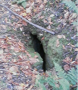
It's not very big, but it goes down 6 or 8 feet, and though it's quite dark down towards the bottom, I'm quite sure there is no snow in there.
Well, that's interesting, I thought, just think if Al Gore knew about this, a famous Snow Hole and there's no snow to be seen. And I headed back, amusing myself with thoughts about how Al might have gotten the Nobel all by himself if he'd known about the Snow Hole, and about how long it would be before the Queen makes him a knight and we have to call him Sir Albert, and whatever. And it was a very pleasant run.
So I got home, and I did a little research. And the first thing I checked is Hopkins Forest, and the O' map is even on line. My route is starting in the lower left corner, going to the upper left corner and back. The field work seems to have been done mostly by Mikell, the cartography by Pat. And the question is -- Is it really an O' map if it has never been used for orienteering? Because I think Williams decided, after the map was done, that it didn't want to open the area up for orienteering. And has this ever happened anywhere else?
And then my next research was about the snow hole. And I found this page and this photo....
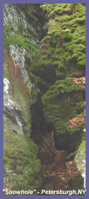
Hmm, seems like I was in the wrong place. Guess I need to go back.
So mid-afternoon I drove up to Petersburg Pass, where Rt. 2 crosses into New York state, and headed north on the trail, taking the map/booklet with me. First stop was a couple hundred yards up the trail, display board with a map of Hopkins Forest (owned by Williams College), that rang a bell, someone, Platt or Dunlavey I thought, had made an O' map of Hopkins Forest once. But the map posted here didn't give credit to either of them.
Onward. A nice trail, and a nice run, over to where a side trail heads off in what seems to be the right spot to find the Snow Hole. And I head off down it and in what seems like just the right distance I come to a couple of not very impressive rocky depressions. Definitely no snow in them. The trail keeps going, down rather steeply, which does not reflect what is on my map, so I go no further, but I search around a little (there are some paths here and there), and I come upon a hole....
It's not very big, but it goes down 6 or 8 feet, and though it's quite dark down towards the bottom, I'm quite sure there is no snow in there.
Well, that's interesting, I thought, just think if Al Gore knew about this, a famous Snow Hole and there's no snow to be seen. And I headed back, amusing myself with thoughts about how Al might have gotten the Nobel all by himself if he'd known about the Snow Hole, and about how long it would be before the Queen makes him a knight and we have to call him Sir Albert, and whatever. And it was a very pleasant run.
So I got home, and I did a little research. And the first thing I checked is Hopkins Forest, and the O' map is even on line. My route is starting in the lower left corner, going to the upper left corner and back. The field work seems to have been done mostly by Mikell, the cartography by Pat. And the question is -- Is it really an O' map if it has never been used for orienteering? Because I think Williams decided, after the map was done, that it didn't want to open the area up for orienteering. And has this ever happened anywhere else?
And then my next research was about the snow hole. And I found this page and this photo....
Hmm, seems like I was in the wrong place. Guess I need to go back.
Monday Oct 15, 2007 #
road running 47:20 [3] 5.2 mi (9:06 / mi)
weight:138lbs shoes: Montrail #2
With Dave, to the top of South Sugarloaf (25:24) and back (21:56). Not so bad going up the hill, 9:13, better than last time I think. Back still sore, and glad I wasn't doing anything longer.
Note
I put this on Charlie's log, but then thought i might as well add it here -- Here is the 1989 version of the O map, with the blue course for the 2nd day of the US Champs.
Note
And here's the last picture in the series, only one I have that could be of the 40s (though it might be 1950)....
.jpg)
Click on the photo for a bigger version with brothers and sister.

Click on the photo for a bigger version with brothers and sister.
Sunday Oct 14, 2007 #
trail running 1:06:51 [3]
weight:137.5lbs shoes: Montrail #2
Bridle path loop on Mt. Toby. Beautiful morning, low 50s, dewpoint 35, though still had a hard time getting out the door. At which point it seemed prudent to make a bargain -- just get out, no need to run hard. So I took it relatively easy for the first part up to the power line, then a little quicker the rest of the way. Felt ok, though lower back muscles are still tight.
Was thinking about my time for the not quite 5K yesterday, and thinking of course how some more training might lower it. But then it occurred to me that conditions were perfect -- cool (almost cold), low humidity, and my legs seem to have some life. In other words, don't get my hopes up about any great improvement. Though that's no reason not to try.
And also wondering about the course length, measured 3.05 in Gmaps Pedometer -- I assume it measures just horizontally and doesn't take into consideration the extra distance when you go up and down hills -- so how long was it really?
Note
Back to the 50s, and it's slim pickings. The only photo I can find (without making a visit to Litchfield, where I'm sure there are quite a few in old family albums) is from 1954, my Little League team, the "Dodgers" (in those days, the real Dodgers still played in Brooklyn). Though for me and others on the team who were on the small side (midget size?), our apparent team name was the "Odger," as the first D was lost under my right armpit and the S spent its time under my left one.
I played second base. At the plate I think I got a lot of walks because of a very small strike zone.
The other thing I remember is that in those days parents, or at least my parents, never came to games. I got there and back on my bike. Parents, one assumes, had better things to do, and certainly didn't worry that if we were out of sight, then we were sure to be kidnapped, or worse. Times have changed....
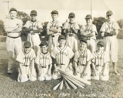
(click on photo for a larger version)
Tomorrow, last stop, the 40s (and my birthday). Dave is coming by for a run at 8:30, so I will have the rest of the day to eat cake. :-)