Training Log Archive: IforIn the 7 days ending Aug 7, 2010:
| ||||||||||||||||||||||||||||||||||||||||
| « | » |
| » now | ||||||||||
| Su | Mo | Tu | We | Th | Fr | Sa | |||||||
Saturday Aug 7, 2010 #
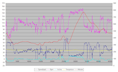
Cycling 1:59:26 42.5 km (21.4 kph) +940m
ahr:114 max:147 shoes: Scale
Loop into the top of the Flumen gorge which the tour must of come up this year with the new tarmac with lots of very new paint on it. A quick but very twisty decent. Then Left and up the col de la Croix de la Serra. This a very steady gradent just the one flatter bit part way up just befor the les Bouchoux turn. Back down off the top and though les Bouchoux on up to the van. Going though the village I past about a 7 year on the side of the road with his proper racer (with tow clips) 50m uo the road he flyes past me but only for anouth 50m by which time I grind back by him.
42.05 01:58:56 21.2 02:03:57 20.3 941 -944 4.4
00:55:13 00:57:46 00:06:27 00:00:00 00:00:00 147 114
 |
| From bike_logs |
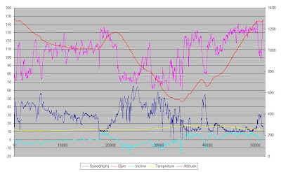
Cycling (road) 2:08:35 45.9 km (21.4 kph) +760m
ahr:116 max:154 shoes: Scale
From Mataflon-Granges down into the l'Ain gorge down river to cross over the bridge at Cize then on to Hautecourt-romaneche and the Col du Berthiand climb. This was not as hard as described in the book whish says it has a 500m section at 15% but the most I saw was 10%. With the heat and my knackered state that was quite enough for me though.
45.924 02:07:35 21.5 02:19:18 19.7 766 -766 3.3
01:10:50 00:31:49 00:22:12 00:03:44 00:00:00 154 116
 |
| From bike_logs |
Friday Aug 6, 2010 #
Cycling (road) 1:42:20 37.8 km (22.2 kph) +670m
ahr:110 max:139 shoes: Scale
A loop taking in the Cote des Rousses. Nice small roads though the woods initaly then the main road for the climb which was fairly easy but busy with trafic. Pleasant ride by the lake back to the Van. lots of sighns of the tour around here as there was a stage finish and start in le Rousses but without getting online I am not sure how the actualy came in and left town.
37.829 01:41:50 22.2 01:51:11 20.4 675 -677 3.5
00:57:58 00:44:22 00:00:00 00:00:00 00:00:00 139 110
 |
| From bike_logs |
Cycling (road) 1:59:00 40.2 km (20.3 kph) +910m
ahr:113 max:161 shoes: Scale
A loop from the top of the Col de la Faucille. Again some realy nice small roads along the top of the ridge then down. A bit slow down as gravely in places and some rocks on the road as well as being small and twisty. Then up the main road climb. Pushed on fairly hard towards the top.
40.222 01:57:40 20.5 02:07:09 18.9 912 -913 4.5
01:02:31 00:36:09 00:12:11 00:07:49 00:00:20 161 113
 |
| From bike_logs |
Thursday Aug 5, 2010 #
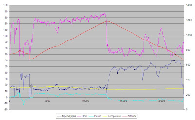
Cycling (road) 2:25:06 51.5 km (21.3 kph) +1030m
A loop around and up to Vue des Alpes. In the Swiss Jura. Just about got most of the ride done in the dry between the overnight and the lunchtime rain. Was feeling fairly tired comming up the hill. No view in and out of the cloud at the top.
I am curently parked up where you will swap from Train to bus if taking the public transport for the WMOC long final tomorow. Not so good planning on my part but my O is so bad I would not make the A final.
51.595 02:24:26 21.4 02:30:40 20.5 1037 -1045 4
01:19:28 01:04:11 00:01:27 00:00:00 00:00:00 146 112
 |
| From bike_logs |
Cycling (road) 1:11:07 22.9 km (19.3 kph) +550m
ahr:109 max:138 shoes: Scale
Col du Mollendruz. For the first time the book and the ground just did not match. I set off up what I though was the right road but just a bit up it I found a big notice board with a good quality big map on it. The map clearly had the col on it with a good B road going up it and an altitude that matched the book. Problem is it started in a village about 4 miles away. The road I was on actualy went to the top of the hill far further and higher than the description. Another road out of the village headed towards the coll but stoped about 2km and 100m higher up above the coll. There only looked to be dirt tracks twisting in between. I went and re-started on the other village and did the col on the other road which had the right climb but all at a good steady gradent unlike the description. From the top of the coll there were only the expected dirt roads that may lead to where the other road from the village was heading.
22.965 01:10:17 19.6 01:32:48 14.8 555 -556 4.8
00:31:19 00:39:48 00:00:00 00:00:00 00:00:00 138 109
 |
| From bike_logs |
Wednesday Aug 4, 2010 #
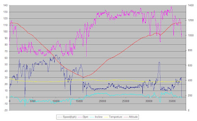
Cycling (road) 3:18:15 72.9 km (22.1 kph) +1460m
ahr:114 max:156 shoes: Scale
Loop over the Ballon de Servance which was not as hard as the book indicated, it talked about 3 kn of 10-12% but in reality only the middle km averages over 10% and the most I saw was 11.5% A very small road though and very little traffic 2 cars up 3 bikes on the way down coming the other way. The around and up the Ballon d'Alsace which is regarded as the first proper tour climb in 1905. A very stedy gradent 6-7% for 9km on a good big but not too busy road. Pushed on a bit towards the top. That's the last of the Vosege tour climbs now onto the Jura where there are not so many.
72.982 03:16:45 22.2 03:34:22 20.4 1468 -1462 4
01:44:51 01:16:36 00:13:55 00:02:53 00:00:00 156 114
 |
| From bike_logs |
Tuesday Aug 3, 2010 #
Cycling (road) 2:40:10 62.3 km (23.3 kph) +1080m
ahr:121 max:155 shoes: Scale
North along the route des cretes to the Col de la Schtucht then same decent down to Munster as yesterday then up the Valled though Metzeral and the steep climb to col du Platzerwasel and back along the ridge to the van. van was out of the cloud setting out but after a few km it was misty and decidedly damp to the Schtucht once a km down though you were out of the cloud and it was nice and sunny in Munster. legs not to bad up the big climb, it's a tough one lots at 9%.
62.339 02:39:20 23.4 02:47:24 22.3 1087 -1090 3.4
01:06:52 01:16:45 00:14:11 00:02:22 00:00:00 155 121
 |
| From bike_logs |
Cycling (road) 2:23:46 57.5 km (24.0 kph) +990m
ahr:124 max:153 shoes: Scale
After Lunch at the van a loop to the south. A long decent to Kruth then down the main valley road to the bottom of the Grand Ballon climb. This passes though the col Amic about half way up. legs not so good especialy on the bottom slops of this got into a decent rythm as things went on though and flew along once up high back to the van. Weather a lot nicer this afternoon lots of people out cyceling. Alot coming up my decent route which was long but fairly steady.
57.544 02:23:46 24 02:29:55 23 994 -996 3.4
00:44:48 01:12:41 00:25:38 00:00:39 00:00:00 153 124
 |
| From bike_logs |
Monday Aug 2, 2010 #
Cycling (road) 2:28:20 50.5 km (20.4 kph) +1110m
ahr:113 max:139 shoes: Scale
50.5 02:27:00 20.6 02:44:14 18.4 1117 -1119 4.4
00:58:47 01:29:33 00:00:00 00:00:00 00:00:00 139 113
 |
| From bike_logs |
Sunday Aug 1, 2010 #
Cycling (road) 1:42:38 37.6 km (22.0 kph) +820m
ahr:119 max:153 shoes: Scale
Col du Bonhomme from ste-marie-aux-mines over the col des bagenelle on route as you actiualy drop onto the Bonhomme which is at a crossroads. Was going steady on the way up but then got someone catching me up so I speeded up a bit and droped them but was then commited to the quicker pace... Lots of people out on bikes. Nice fast decent back the way I had come.
37.646 01:42:18 22 01:48:32 20.8 826 -823 4.3
00:45:41 00:29:24 00:24:20 00:03:13 00:00:00 153 119
 |
| From bike_logs |
Cycling (road) 1:45:39 37.0 km (21.0 kph) +770m
ahr:111 max:138 shoes: Scale
col du Calvaire. Started a couple of km from the top did a loop down though Orbey. A very fast decent. Up the main road was not so nice too many cars out on a butifull Sunday afternoon. The gradent is all very steady just span the legs out not being able to push at all. Lots of people around large numbers out picking wimburys.
37.043 01:45:09 21.1 01:48:22 20.5 770 -769 4.1
00:48:37 00:57:02 00:00:00 00:00:00 00:00:00 138 111
 |
| From bike_logs |