Training Log Archive: PGIn the 7 days ending May 23, 2019:
| ||||||||||||||||||||||||||||||||||||||||||||||||||||||||||||||||||
| « | » |
| » now | ||||||||||
| Fr | Sa | Su | Mo | Tu | We | Th | |||||||
Thursday May 23, 2019 #
12 PM
orienteering 1:11:54 [2] 3.26 mi (22:03 / mi) +428ft 19:37 / mi
weight:139lbs
For some unknown reason the idea popped into my brain that it would be fun to have a go at Sanjay's advanced course at Mt. Norwottuck that was used Tuesday evening. I'd already been to all the points with him on Sunday, so that was obviously an advantage, but I still was curious about how I would manage. And so, within about 15 minutes, I was out the door and heading down there.
It was quite good fun. The upside was trying out different routes, so it wasn't just following the route we'd taken on Sunday, and managing to deal pretty well with the problems with the map. The downside was my left butt hurts when I walk energetically, especially uphill, and so it was bothering me most of the time. Still, on balance, it was a positive experience.
The map/course with Charlie's route:
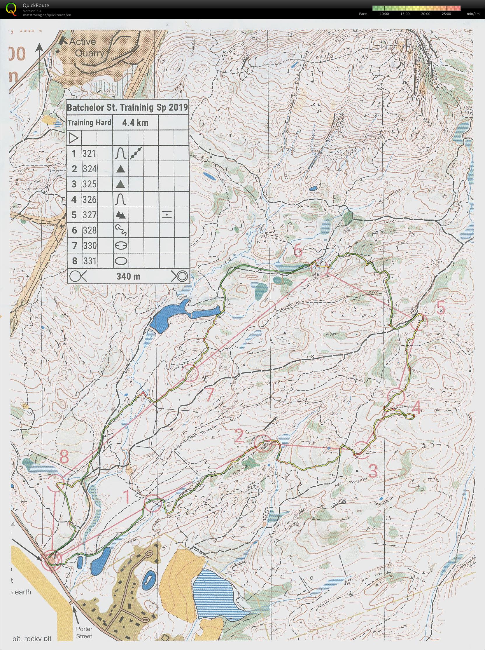
My route:
1. Same as Charlie.
2. Left of the line, staying up on the slope, just looking for the line of least resistance.
3. Left of the marsh, east to the trail junction, southeast to the boulder. Phil's right, it's located at the east edge of the circle.
4. Straight, reading the contours.
5. Figured out to the trail on the left was faster, but felt like going straight. Been the first part of the route with Sanjay.
6. Very similar to Charlie's route, just cut the corner at little right at the beginning. With Sanjay we had gone NW right from 5, picked up an unmapped trail just before the mapped one, and spent some time going route the right direction but with no idea where we were. So this all seemed new.
7. South (straight up) from 6, picked up an unmapped trail running down the gentle spur just north of the mapped one, followed it WSW for a bit, then hopped over to the mapped. All was just fine for a while, saw the long marsh on my left, and then nothing made sense -- T junction, choice of left or right when I just wanted to go straight. So I went straight anyway, through various ups and downs, mostly ups, always an eye on the compass. And after a while there was the proper depression.
8. Due south to the main trail, and then the rest was obvious.
F. Due south to the trail, left, then right.
So no real mistakes, walked aggressively, seems to have been good enough for first in M75, my first time in that age group. :-)
And then, in the spirit of Phil's training events, stopped for refreshments on the way home. Not the usual adult beverages, after all it was early afternoon. But a small dish of chocolate almond ice cream seemed a suitable substitute.
--------------
The map really is a shame. Obviously the whole thing should be redone. But I think you could have a decent product for casual use if the trails were just mapped properly. At maybe one-tenth the work.
It was quite good fun. The upside was trying out different routes, so it wasn't just following the route we'd taken on Sunday, and managing to deal pretty well with the problems with the map. The downside was my left butt hurts when I walk energetically, especially uphill, and so it was bothering me most of the time. Still, on balance, it was a positive experience.
The map/course with Charlie's route:
My route:
1. Same as Charlie.
2. Left of the line, staying up on the slope, just looking for the line of least resistance.
3. Left of the marsh, east to the trail junction, southeast to the boulder. Phil's right, it's located at the east edge of the circle.
4. Straight, reading the contours.
5. Figured out to the trail on the left was faster, but felt like going straight. Been the first part of the route with Sanjay.
6. Very similar to Charlie's route, just cut the corner at little right at the beginning. With Sanjay we had gone NW right from 5, picked up an unmapped trail just before the mapped one, and spent some time going route the right direction but with no idea where we were. So this all seemed new.
7. South (straight up) from 6, picked up an unmapped trail running down the gentle spur just north of the mapped one, followed it WSW for a bit, then hopped over to the mapped. All was just fine for a while, saw the long marsh on my left, and then nothing made sense -- T junction, choice of left or right when I just wanted to go straight. So I went straight anyway, through various ups and downs, mostly ups, always an eye on the compass. And after a while there was the proper depression.
8. Due south to the main trail, and then the rest was obvious.
F. Due south to the trail, left, then right.
So no real mistakes, walked aggressively, seems to have been good enough for first in M75, my first time in that age group. :-)
And then, in the spirit of Phil's training events, stopped for refreshments on the way home. Not the usual adult beverages, after all it was early afternoon. But a small dish of chocolate almond ice cream seemed a suitable substitute.
--------------
The map really is a shame. Obviously the whole thing should be redone. But I think you could have a decent product for casual use if the trails were just mapped properly. At maybe one-tenth the work.
Wednesday May 22, 2019 #
4 PM
biking - dark blue bike 40:47 11.05 mi (3:41 / mi) +310ft 3:36 / mi
ahr:129 max:152 weight:139lbs
Short loop to Montague Center and back, out via 47 (a little hillier), back along the river. Good steady effort. low 70s, north breeze, sunny and low humidity. :-)
Tuesday May 21, 2019 #
2 PM
biking - dark blue bike 1:24:21 17.19 mi (4:54 / mi) +1717ft 4:29 / mi
ahr:132 max:159 weight:139lbs
Nice day, sunny, mid-60s, but very windy, out of the northwest more or less. Started on the west side of the valley and did a loop in the Conway hills, which had the benefit, given the hills and the woods, of pretty much neutering the wind. Not teat it wasn't still windy, but it just didn't seem to matter much when you're going up or down all the time.
A second benefit was that I need to be getting out on both the hills and the dirt roads, and today's route, though short, had plenty of both.
Have to say I enjoyed it.
A second benefit was that I need to be getting out on both the hills and the dirt roads, and today's route, though short, had plenty of both.
Have to say I enjoyed it.
Monday May 20, 2019 #
5 PM
biking - dark blue bike 48:31 12.63 mi (3:51 / mi) +99ft 3:49 / mi
ahr:118 max:140 weight:139lbs
Short ride, just north up the river and back, almost flat. Warm, windy from the west.
Sunday May 19, 2019 #
6 AM
orienteering 2:17:21 [1] 3.98 mi (34:31 / mi) +433ft 31:17 / mi
weight:139lbs
Sanjay is setting courses for Tuesday's O' session on the south side of Norwottuck, and when I saw him at Earl's Trails on Thursday, I'd offered to check the controls on the advanced course. It turned out the easiest way to do that was to go out with him and take care of checking the control sites and hanging the flags at the same time.
So we were off a little before 7, nice morning. A couple of hours of tromping around. Excellent company and conversation. And our orienteering was OK even when the map had issues.
Managed to bust the baseplate on my compass -- slipped just once when the rock I'd stepped on rolled, put a hand down to catch myself and came up with half a compass. Must have already had a crack in it. As for me, a little achy from the overall effort but no apparent damage done.
And the timing was excellent. Five minutes after I got home it was pouring.
Saturday May 18, 2019 #
4 PM
biking - dark blue bike 1:07:02 16.02 mi (4:11 / mi) +755ft 4:00 / mi
ahr:125 max:146 weight:139lbs
Low 70s, some wind at times but I can't really remember which way. As that might indicate, not in any hurry, because the quads were feeling the last couple of days. And therefore no point in using the e-gizmo.
Feeling a bit weak by the end. Might need to start taking a little food along. Though probably first place to start would be some water. Actually did have some, I think maybe 2 or 3 ounces in the bottle. Drank about half of it.
Feeling a bit weak by the end. Might need to start taking a little food along. Though probably first place to start would be some water. Actually did have some, I think maybe 2 or 3 ounces in the bottle. Drank about half of it.
Friday May 17, 2019 #
4 PM
biking - dark blue bike 1:04:20 17.24 mi (3:44 / mi) +427ft 3:39 / mi
ahr:129 max:156
Assumed I'd be rained out today, but the rain moved out mid-afternoon and things were starting to dry out. No reason not to venture out. Mid-60s, S 5 or so, dewpoint up to about 60.
Plus, with my new e-assist gizmo, the miles go by just a little quicker. Can't wait to ride with Charlie again.
Plus, with my new e-assist gizmo, the miles go by just a little quicker. Can't wait to ride with Charlie again.