Training Log Archive: TheInvisibleLogIn the 7 days ending Apr 21:
| ||||||||||||||||||||||||||||||||||||||||||||||||||||||||||||||||||
| « | » |
| » now | ||||||||||
| Mo | Tu | We | Th | Fr | Sa | Su | |||||||
Saturday Apr 20 #
Real Orienteering race 1:02:45 [4] *** 5.16 km (12:10 / km) +306m 9:23 / km
ahr:120 max:138 spiked:7/8c shoes: XA Pro 3D
After a small wobble going to the first, spiked the following 8 controls until abandoning the course at course closure time. Reason - started too late. Reason - spent almost 2 hours managing computer until leaving to run. Reason - too many enter-on-days, too few computer volunteers and those that do volunteer are in the Saturday morning offspring sport stage. Outcome - looking for better system. Solution - proposal that EODs in future draw their own course on an all controls map, download on SIME and have no result on eventor. This would dramatically simplify the management of the entry desk and hopefully mean more would be willing to volunteer. The aim is not to punish EODS but to make volunteering simpler. If you want an official result, maybe you should enter online. If you don't want an official result, then fine, but you run the risk of map shortages.
Friday Apr 19 #
Walking 2:15:00 [1] 9.0 km (15:00 / km)
Mediocre 90s after a flashy first 9 42 followed by a shitty second 9 in the 50s.
Thursday Apr 18 #
Note
First stage of the Enfield project. All automatic thus far, but lots of processing time, problems with OCAD XML code and some confusion with projections. The green means what you expect. The purple is slow undergrowth. There is the option for 10 metre contours, but I have kept 5 in for now as so much detail disappears with 10.

Running 38:04 [3] 5.34 km (7:08 / km) +55m 6:47 / km
shoes: Saloman Pulsar red
Hard work. Still in post-rogaine slump.
Tuesday Apr 16 #
Walking 2:15:00 [1] 9.0 km (15:00 / km)
94. Could have been much better but the greens dried and became lightning fast as well as having been cored. Couldn't putt to save myself in the second nine.
Monday Apr 15 #
Note
Reflection on Victorian Rogaining maps.
I heard of some grumbles about the poor quality of the map after the event. Supposedly the grumbling came from someone who did very well on the day, but is used to orienteering standard mapping. (It wasn't me - my results were more mediocre and I knew what to expect)
My understanding is the Victorian rogaining has a digital archive of VicMap maps that date from 20+ years ago. When I say digital, I suspect digital as in raster images rather than digital data. I know a little of the history of these contours. Originally VicMaps were based on analog photogrammetically derived contours. These were then digitised by hand.I saw the process of digitising these contours to make a 10 metre DEM some decades ago. It was happening in my workplace. The 10 metre DEM points were interpolated from raster images of the analog contours. I suspect that the version of the contours used in Victorian rogaines have been digitally re-created from these interpolated DEM points. Its little wonder the contours are so poor.
In 2005 I was frustrated with this situation so I created a rogaining map on the outskirts of Bendigo with 5 orienteering maps and a number of street maps. It was a lot of work, not the sort of process I was willing to repeat. The reaction to the map at the subsequent rogaine was interesting. The orienteers who attended loved it. Some rogainers were not convinced this was rogaining because it was too accurate. Today there is publicly available digital data that would allow one to bypass orienteering maps as a base.
I went on a search of maps used for recent World Rogaining Championships. Last years World Championship was held in the Sierra Nevada mountains. Here is a link to the model map.
https://cal-o-fest.com/public/docs/Martis%20Peak%2...
Some quick observations:
1. It is clear the map (including contours and vegetation) has been created using lidar data and either OCAD or Kartapullautin.
2. Magnetic north
3. An adaption of ISOM17 symbology.
The 2023 WRC was held as the climax of a 10 day North American orienteering carnival. Perhaps these map features are an aberration. I went on a further search. Its hard to find online maps of past rogaining championships, but I did manage to locate a few.The 2022 WRC was held in the Czech Republic.
https://play-map.com/event?id=736〈=english
Observations
1. Evidence of use of lidar data in the shapes of the mapped clearings. Unsure about contours. Suspect lidar information on green has been suppressed.
2. Magnetic North
3. An adaptation of ISOM17 symbology.
Go back to 2015 in Finland.
http://www.tulospalvelu.fi/gps/20150822wrc/
1. Those contours look autogenerated from digital data. Whether lidar or not I am unsure. Perhaps just a DEM.
2. Map is oriented to grid north but the magnetic lines are shown on the map.
3. A looser adaptation of the pre-ISOM17 symbology.
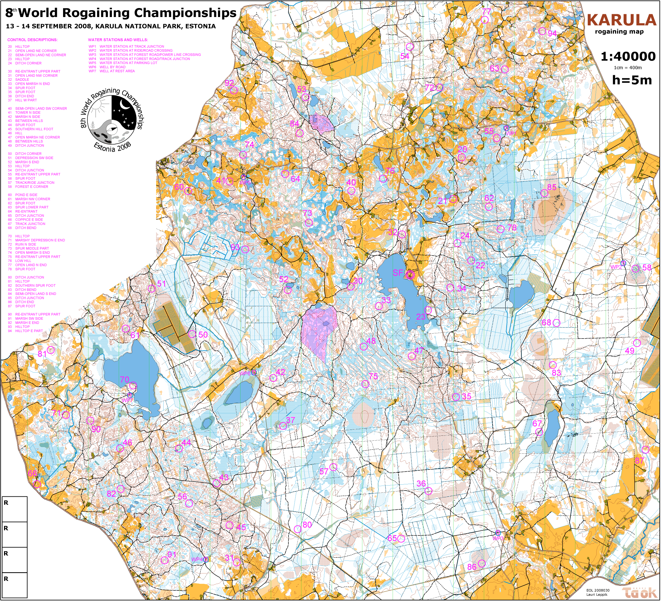
Going back further to Estonia 2008. I heard horror stories of the wet in this event.
https://8wrc2008.rogain.ee/failid/wrc2008map.gif
1. Not sure about contours and veg generation.
2. No sign of north lines...
3. Clearly the cartographer comes from a background of orienteering mapping.
I looked at a few Championship maps in the rest of Australia. It seems to vary according to State, but the ACT is a more advanced example.
https://store.avenza.com/cdn/shop/products/2023042...
1. The map was created using QGIS which suggests some digital data. The vegetation representation is clearly digitally derived, perhaps with a LasTools routine.
2. Magnetic North
3. Some concordance with orienteering symbology - black tracks.
So back to your typical Victorian rogaining map - poor contours, grid north, weird colours (red roads through pink out of bounds). Worst though for the event this weekend was the lack of discrimination between open and thick areas of the map. You needed inside information (rogained here before) to know that the west was open and the east was progressively thicker. Making the wrong choice at the start would determine which half of the field you finished in.
Why does Victoria persist with its form of map? Its not to be consistent with what is happening to the sport in other countries. Digitally-created rogaining maps appear to be standard already overseas. The future of rogaining maps in Europe will be digitally derived maps using kartappullautin and MapAnt. Most of Scandinavia is now covered by lidar derived maps. Check out the "Orienteering Map" covering all Norway.
https://mapant.no/#1/60/10
The MapAnt map is described as good enough for orienteering training, meaning its certainly good enough for a rogaine if scale issues can be sorted. This approach has spread to some other European countries and is only limited by the differential public release of lidar data. If you are in Australia and you need to train for a WRC on similar maps to that you will enounter overseas, you need to go use orienteering maps. The skill of guesswork required in Victorian rogaining maps is irrelevant to WRC events. I could assume that no-one in the sport has developed the skills to use the available digital data - but I know that is not true. Is it culture, with Victoria being the location with the greatest organisational separation between orienteering and rogaining? Rogaining started in Victoria with little connection to orienteering. In much of the rest of the world the two sports are more symbiotic. Maybe history is a constraint?
I don't know the answer to these questions. The main constraint in my mind is the patchy availability of public lidar data in Victoria. Though far from a full coverage, ther eis enough to make a start, including for the site of yesterday's rogaine. If I am going to whinge about something that is done in a volunteer sport, then I should be prepared to contribute to change. I have already started the download process for data for the Enfield forest and I plan to build a digital map using that lidar data and OSM track data. I will release this to whoever wants to use it.
I heard of some grumbles about the poor quality of the map after the event. Supposedly the grumbling came from someone who did very well on the day, but is used to orienteering standard mapping. (It wasn't me - my results were more mediocre and I knew what to expect)
My understanding is the Victorian rogaining has a digital archive of VicMap maps that date from 20+ years ago. When I say digital, I suspect digital as in raster images rather than digital data. I know a little of the history of these contours. Originally VicMaps were based on analog photogrammetically derived contours. These were then digitised by hand.I saw the process of digitising these contours to make a 10 metre DEM some decades ago. It was happening in my workplace. The 10 metre DEM points were interpolated from raster images of the analog contours. I suspect that the version of the contours used in Victorian rogaines have been digitally re-created from these interpolated DEM points. Its little wonder the contours are so poor.
In 2005 I was frustrated with this situation so I created a rogaining map on the outskirts of Bendigo with 5 orienteering maps and a number of street maps. It was a lot of work, not the sort of process I was willing to repeat. The reaction to the map at the subsequent rogaine was interesting. The orienteers who attended loved it. Some rogainers were not convinced this was rogaining because it was too accurate. Today there is publicly available digital data that would allow one to bypass orienteering maps as a base.
I went on a search of maps used for recent World Rogaining Championships. Last years World Championship was held in the Sierra Nevada mountains. Here is a link to the model map.
https://cal-o-fest.com/public/docs/Martis%20Peak%2...
Some quick observations:
1. It is clear the map (including contours and vegetation) has been created using lidar data and either OCAD or Kartapullautin.
2. Magnetic north
3. An adaption of ISOM17 symbology.
The 2023 WRC was held as the climax of a 10 day North American orienteering carnival. Perhaps these map features are an aberration. I went on a further search. Its hard to find online maps of past rogaining championships, but I did manage to locate a few.The 2022 WRC was held in the Czech Republic.
https://play-map.com/event?id=736〈=english
Observations
1. Evidence of use of lidar data in the shapes of the mapped clearings. Unsure about contours. Suspect lidar information on green has been suppressed.
2. Magnetic North
3. An adaptation of ISOM17 symbology.
Go back to 2015 in Finland.
http://www.tulospalvelu.fi/gps/20150822wrc/
1. Those contours look autogenerated from digital data. Whether lidar or not I am unsure. Perhaps just a DEM.
2. Map is oriented to grid north but the magnetic lines are shown on the map.
3. A looser adaptation of the pre-ISOM17 symbology.
Going back further to Estonia 2008. I heard horror stories of the wet in this event.
https://8wrc2008.rogain.ee/failid/wrc2008map.gif
1. Not sure about contours and veg generation.
2. No sign of north lines...
3. Clearly the cartographer comes from a background of orienteering mapping.
I looked at a few Championship maps in the rest of Australia. It seems to vary according to State, but the ACT is a more advanced example.
https://store.avenza.com/cdn/shop/products/2023042...
1. The map was created using QGIS which suggests some digital data. The vegetation representation is clearly digitally derived, perhaps with a LasTools routine.
2. Magnetic North
3. Some concordance with orienteering symbology - black tracks.
So back to your typical Victorian rogaining map - poor contours, grid north, weird colours (red roads through pink out of bounds). Worst though for the event this weekend was the lack of discrimination between open and thick areas of the map. You needed inside information (rogained here before) to know that the west was open and the east was progressively thicker. Making the wrong choice at the start would determine which half of the field you finished in.
Why does Victoria persist with its form of map? Its not to be consistent with what is happening to the sport in other countries. Digitally-created rogaining maps appear to be standard already overseas. The future of rogaining maps in Europe will be digitally derived maps using kartappullautin and MapAnt. Most of Scandinavia is now covered by lidar derived maps. Check out the "Orienteering Map" covering all Norway.
https://mapant.no/#1/60/10
The MapAnt map is described as good enough for orienteering training, meaning its certainly good enough for a rogaine if scale issues can be sorted. This approach has spread to some other European countries and is only limited by the differential public release of lidar data. If you are in Australia and you need to train for a WRC on similar maps to that you will enounter overseas, you need to go use orienteering maps. The skill of guesswork required in Victorian rogaining maps is irrelevant to WRC events. I could assume that no-one in the sport has developed the skills to use the available digital data - but I know that is not true. Is it culture, with Victoria being the location with the greatest organisational separation between orienteering and rogaining? Rogaining started in Victoria with little connection to orienteering. In much of the rest of the world the two sports are more symbiotic. Maybe history is a constraint?
I don't know the answer to these questions. The main constraint in my mind is the patchy availability of public lidar data in Victoria. Though far from a full coverage, ther eis enough to make a start, including for the site of yesterday's rogaine. If I am going to whinge about something that is done in a volunteer sport, then I should be prepared to contribute to change. I have already started the download process for data for the Enfield forest and I plan to build a digital map using that lidar data and OSM track data. I will release this to whoever wants to use it.